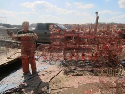
Because of rising water, Bobby Abner is planning to raise the pier at his family business for the second time. (Photo: Sydney Paul)
CHESAPEAKE BEACH, Md.—For Bobby Abner, keeping his business above water isn’t a metaphor.
He is about to raise the pier for the family fishing, restaurant and marina business for the second time in 20 years to stay above rising sea levels in the Chesapeake Bay.
His father built a pier there in the late 1950s that was even with the side of his fishing boat, Abner said.
“For years and years and years, it was very adequate. Then in about the early 1990s, late 1980s, we had to raise the pier a foot and a half, because the tide was coming up so high you almost needed a ladder to get up on the boat. Now we’re going to have to raise it again soon.”
The water level in the Chesapeake Bay is getting higher, a combination of the sea rising 3 to 4 millimeters and land sinking about 7 millimeters per year, according to some tide measuring stations.
Despite this, and to keep his family business going for another generation, Abner is not only raising the pier, he’s raising the ground—and planning to build a six-story condo building on the edge of the rising tides of Fishing Creek.
“We’re going to build a 52-unit condo back here,” Abner said.
Abner’s story sits at the crossroads of rising sea level and Maryland’s dependence on development of waterfront property.
Maryland’s shoreline is 7,700 miles including coastal inlets, according to updated measurements by the Maryland Geological Survey. The bay and ocean coasts have some of the most highly prized real estate in the state, and some of the most threatened. While the state depends on tax revenue and shore tourism dollars, regulators struggle to find a balance that also protects the resources of the Chesapeake from overdevelopment.
Established in 1984, Maryland’s Critical Area Commission is charged with balancing the drive for development with the need to protect the natural resources of the bay from the strain of pollution and stress on wildlife.
While it has a hand in local development issues, however, the commission did not originally address the issue of sea level rise that threatens many of these developed areas.
Then in 2008, Maryland passed the Living Shoreline Protection Act and amended the Chesapeake and Coastal Bays Critical Area Act to give the state more authority to regulate shoreline buffers.
The legislation was intended to protect natural resources and limit growth in areas vulnerable to rising sea levels.
However, developments like Abner’s likely will continue, because the state leaves decision-making in the hands of local zoning authorities. Chesapeake Beach, like many places, accounts for flood tides but not for sea level rise in its building code.
***
On top of global sea level rise, a slowing Gulf Stream and sinking continental plate are compounding the problem of sea level rise in the Chesapeake.
The level of the Chesapeake Bay has risen 1 foot in the last 100 years, or just over 3 millimeters a year. That rate abruptly accelerated since 1987, according to research by John Boon, marine scientist with the Virginia Institute of Marine Sciences. It is now rising by as much as 4 millimeters a year at some tide stations.
The acceleration is cumulative, meaning the annual rate of rise is increasing from year to year, Boon said in an interview.
“Acceleration in the rate of sea-level rise has the kind of compound effect you see in a savings account, or with credit-card debt,” Boon wrote in the Journal of Coastal Research in October 2012. “It’s not just that sea level is increasing, but that the rate at which it’s increasing is increasing as well. That can cause future sea level to be significantly higher than if the rise rate were constant.”
Conservative estimates predict between 2 and 5 feet of extra water on the bay’s shores before the end of this century.
The problem affects more than just your beach vacations. It conflicts with our nation’s preference for living and developing the waterfront, and the tourism and development revenue that brings.
“One half, roughly, of our population lives in coastal watershed counties,” said Virginia Burkett, chief scientist for global change research at the U.S. Geological Survey, in an April Google+ Hangout on sea level rise. “More than one half of our GDP, some studies indicate, comes from these coastal watershed counties. The risk, the exposure, for our society is much greater than it has been.”
***
Although on hold, Abner’s condominium plans will bring more people to live at the water’s edge, and he realizes time and the tides are against him.
“In order to do that, we’re going to have to raise (the land) 4 more feet. It seems like the tide rises more and more now.”
Since his father built his first pier in 1957, Abner has enlarged the family business, adding Abner’s Crab House in 1966, expanding with the marina in 1969, and raising his dad’s docks to adapt to sea level rise. The combined commercial fishing, restaurant and marina operations now sustain his eight grown children.
The town of Chesapeake Beach has grown with the Abner family. Over the past three decades, the town has undergone a surge of predominantly beachfront development—much of it in areas threatened by rising sea levels and storm tides blowing in from the Chesapeake Bay.
Abner’s proposed project, Fishing Creek Condominiums, would sit on his current marina—land once part of a railroad that ran from Seat Pleasant to the Rod & Reel resort on the beach across the highway. Originally filled-in marshland, the ground floods several times a year, he said.
From his vantage point, state regulations, more than rising waters, are choking his family business.
State and local regulators say his plans have been stalled by the local zoning code and by laws passed in the 1980s to protect the Chesapeake Bay watershed. Abner’s Marina is part of the state’s Chesapeake Bay Critical Area.
***
Maryland’s Critical Area Act was the keystone effort by state lawmakers to allow development while limiting its impact on the Chesapeake Bay. The act identifies as critical all areas within 1,000 feet of the Chesapeake Bay, its tributaries, tidal waters and tidal wetlands in the State of Maryland. The last 100 feet of those lands make up the critical area buffer and must be maintained in as natural a state as possible to help filter runoff and protect the Chesapeake from pollution.
Beginning in 2008, Maryland stepped up regulation of critical areas, in part to address climate change and sea level rise, said Zoe Johnson, program manager for Maryland’s Office for Sustainable Future.
The 2008 amendment also required the Critical Area Commission to keep pace with sea-level rise and new mapping technology by providing a new map of the critical area boundary every 12 years. Other changes include increasing the buffer zone in some more vulnerable areas from 100 to 200 feet.
Ultimately, however, decisions on what to approve or deny are made at the local planning agency level, said Ren Serey, executive director of the Critical Area Commission. Local planners are responsible for developing and enforcing land-use policies for the critical areas within their boundaries—provided those policies meet state standards.
The 29-member commission is appointed by the governor and approved by the Maryland Senate. Commissioners don’t see local projects. Those are reviewed and commented on by commission staff before they are returned to the local planners for a final approval.
The commission also has authority to review local approvals and appeal them to the court system if they violate the critical area law or its intent. Serey said they appeal three to five projects a year.
Before the economy changed, the commission reviewed about 2,000 proposals a year, Serey said, of which 900 were new construction. “The totals for recent years are approximately half the prior numbers, but they appear to be starting to rise,” he said.
Critical area land is categorized in three progressively more restrictive grades, based on land use in 1985, when the first maps of the critical area were drawn up: “intensely developed,” “limited development” and “resource conservation” areas.
In all three, development similar to what is already nearby is allowed, with restrictions in place to reduce pollution runoff, habitat destruction or other activity that could harm the bay. Less than 20 percent of the critical area was developed at the time the first maps were drawn, according to the commission Web site.
The commission was fully up and running by about 1990, Serey said.
Since that time, there has been significant residential development in about 15 percent of the census blocks that could be under water within the century, an analysis by Capital News Service analysis found. The number of homes in those neighborhoods doubled.
***
If Abner or his sons can adapt the condo project to comply with critical area law and local zoning, the building is likely to move forward.
The land is part of Chesapeake Beach’s town center zoning and designated as an “intensely developed area” under the critical area law. The designation allows for undeveloped portions to be built up to the level of surrounding properties while using the buffer restrictions to reduce pollution runoff.
Abner’s proposal did not do enough to show how he would protect and maintain the 100-foot buffer zone to manage stormwater runoff into Fishing Creek and the marshland behind the marina, according to commission documents. An endangered species assessment must also be conducted.
The plan calls for the condo to be raised over the land the marina now occupies, with the ground level set aside for parking. That elevation satisfies the state’s tougher floodplain regulations, but that pushed the roof line 7 feet higher than town zoning allows.
To complicate matters, Chesapeake Beach town planner Bill Watson said Abner started renovating the second floor of the Crab House without necessary approvals, triggering a stop-work order on that project.
“Abner’s been his own worst enemy on the regulation side of things in the past,” Watson said, “but he’s been making a sincere effort to work with the town since then.”
Even if the project meets state and local standards, the facts of higher tides and sea level rise could make living there tricky. The Crab House parking lot and street leading toward the marina flood during especially high tides now. A severe storm, like the 8 feet of water pushed in by Tropical Storm Isabel in 2003, could leave residents stranded in 3 to 4 feet of water, flooding the parking level and any cars left there.
Very few land-use agencies require waterfront developers to take sea level rise into account, Johnson said. The state offers funding to local agencies for sea level rise and other ecological assessments on a case-by-case basis, but Chesapeake Beach has not taken advantage of that program. Watson said he was not aware of the program.
When reviewing state-owned building projects, regulators require adaptation to a 50-year, sea-level-rise estimate of at least 2 feet above today’s mean sea level, she said, because most projects aren’t expected to last much longer than 50 years.
Local agencies still rule when it comes to commercial development, Johnson said.
Those agencies don’t have the resources to deal with long-term climate change implications, said Watson. Chesapeake Beach depends on state and federal emergency planners for general guidance in planning for disasters 50 to 100 years in the making.
“I have seen bright ideas that look good on paper that didn’t work out that well in practicality,” he said. “Until you try it and see what the impact is, sometimes it’s hard to tell what the effect is going to be.”