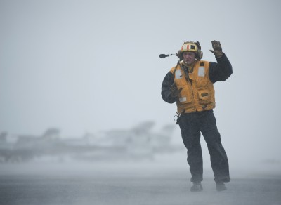
PACIFIC OCEAN (May 7, 2012) Aviation Boatswain's Mate (Handling) 2nd Class Jathan Lane directs the movement of aircraft during foul weather on the flight deck aboard the Nimitz-class aircraft carrier USS Carl Vinson (CVN 70). Carl Vinson and Carrier Air Wing (CVW) 17 are deployed to the U.S. 7th Fleet area of operations. (U.S. Navy photo by Mass Communication Specialist 2nd Class James R. Evans/Released) More photos are available here.
DAHLGREN, Va. (June 21, 2012)—A newly discovered radar capability to detect individual cloud hydrometeors in the free atmosphere can impact future performance of combat systems and military decision making, Navy scientists announced today.
The technical details of the capability - made possible with a very high-resolution Doppler radar - are expounded in a paper entitled "Radar Observations of Individual Rain Drops in the Free Atmosphere" published in the Proceedings of the National Academy of Sciences journal May 28.
"This series of experiments demonstrate classic science," said Dr. Mark Anderson, a Naval Surface Warfare Center Dahlgren Division (NSWCDD) principal systems scientist who co-authored the paper. "The Navy's ultimate hope in understanding these cloud formations is to improve the description and forecasting of severe weather which in-turn would help the Navy and DoD (Department of Defense) in evaluating systems performance and in day-to-day decision making."
The Naval Research Laboratory (NRL) multi-agency study revealed the unexpected and is improving scientists' understanding of the dynamics and structure of cloud systems.
"The signal processing of the radar returns revealed that these cloud details led to the unanticipated observations of individual rain drops - a first ever observation through remote sensing means," explained Anderson.
A team of specialists - spanning an area of expertise from cloud physics and dynamics to radar theory, design, and applications - coordinated the series of weather experiments with the Naval Ordinance Test Unit, the Federal Aviation Administration, the Cape Canaveral Air Force Station Facility, and NASA between 2008 and 2010.
Atmospheric remote sensing has played a pivotal role in the increasingly sophisticated representation of clouds in the numerical models used to assess global and regional climate change.
This modeling is successful because the bulk cloud properties are based on statistical analysis of the returned microwave signals scattered by diverse particles comprised of numerous, perhaps billions, of cloud hydrometeors illuminated within a given radar pulse volume.
"The study has shown that it is now possible to combine bulk measurements with nearly simultaneous measurements of the individual cloud particles themselves," said the NRL study's lead author, Dr. Jerome Schmidt.
Schmidt and his team of scientists hope that such coupling with a single instrument will lead to new understanding of the dynamics and structure of the cloud systems that exert a strong control on our everyday weather and long-term climate.
They expect their research to motivate the design of new weather research radars which will help unlock remaining secrets of cloud and precipitation formation such as the development and movement of large hail stones which lead to over a billion dollars in damage annually to crops and property in the United States alone.
"The original intent of the study was to establish methods that accurately measure NRL's ability to predict various forms of stormy weather and cloud liquid and ice water content," said Anderson. "As the experiments progressed, the team began to realize that they were observing cloud structures with a radar at the unprecedented range resolution of 0.5 meters - a world's best."
In addition to studying the properties of various cloud systems, the experiments evaluated the ability of the U.S. Navy's Mid-Course Radar to retrieve information on the internal cloud flow and precipitation structure.
The team used an instrumented research aircraft to conduct field projects during the height of the Florida summer convective season to collect radar data, launch weather balloons and collect "in situ" (in position) cloud data.
The scientists documented other features of the local cloud systems using a variety of complimentary surface-based sensors and cameras which continually monitor the sky conditions and guide the placement of the aircraft and the high-resolution radar beam.
The result of one study captured the structure of a deep convective cloud system as it passed over the vertically pointed radar and revealed both the bulk radar reflectivity structure and the nature of individual rain drops which appear as linear streaks while traversing the narrow radar beam on their way to the surface.
The multi-agency effort included scientists from NRL's Marine Meteorology Division, NSWCDD Strategic and Weapon Control Systems Department, the Scripps Institution of Oceanography, Johns Hopkins University Applied Physics Laboratory, L-3 Interstate Electronics Corp., Radar Technology Specialists Corp., Weather Modification, Inc., and students from universities as far away as the Institute of Geophysics located at the University of Warsaw, Poland.
The paper can be accessed directly on the Proceedings of the National Academy of Sciences website: http://www.pnas.org/content/early/2012/05/25/1117776109.full.pdf+html?sid=6e3a4c16-b390-4505-90b5-f5f119d3285c


