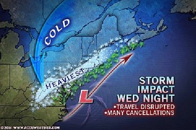
STATE COLLEGE, Pa. (January 26, 2011) — AccuWeather reports a snowstorm will cause dangerous travel and disruptions to activities from Washington, D.C., to Boston and other areas in the Northeast through tonight and into Thursday morning.
Expert Senior Meteorologist Alex Sosnowski stated, "We have two main pulses with this snowstorm."
The first pulse of locally heavy snow was moving northeastward from the Philadelphia area and into New York City and southern New England during the midday.
The morning commute in the Philadelphia area was one of the worst in recent memory for many people caused by the thump of snow.
"Up to half a foot of snow was falling from the first part of the storm alone over areas in southeastern Pennsylvania, New Jersey and Metropolitan New York," Sosnowski said.
The second part of the storm potentially may be heavier and more disruptive than the first.
This second pulse of snow will hit many areas as the sun is going down or after dark, when road surface temperatures are cooling.
As a result more of that snow will stick to more roads in more areas. The snow will also roll eastward into areas that get rain from the first part of the storm, including the Jersey cape and the Delaware beaches.
"A change to rain, wintry mix and even a lull in the Washington/Baltimore to Philadelphia New York City slot during the afternoon Wednesday will have many people think the storm is over or even a bust," Sosnowski said.
That lull will allow some of the snow will melt off and road conditions will improve for a time. However the second batch of heavy snow will roll from southwest to northeast later in the afternoon and evening.
The lull may pencil out over New England and part of the New York City area.
Much of the swath from Philadelphia to Boston is in store for a 6- to 12-inch snowfall. Washington/Baltimore, D.C. can expect a total of 2 to 6 inches from the storm, their biggest snowfall of the season so far.
Areas just north and west of these cities will get the heaviest amounts, because of slightly lower temperatures and less melting at midday compared to urban effect of the major cities.
It will be during the evening and early overnight hours that the storm will intensify just to the southeast of Cape Cod as the upper-level storm catches up with it.
As this happens, snow will fall heavily from northern New Jersey through southeastern New York and southeastern New England.
Snowfall rates of 1 to 3 inches an hour are possible in heavy snow bands that develop.
Some portions of the mid-Atlantic and southeastern New England may experience thunder and lightning with the snow.
As the storm intensifies tonight, the wind will also increase, contributing to more travel concerns by blowing snow around.
The heavy snowfall rates, gusty winds and falling temperatures behind the storm will make it hard for roadway crews to keep up.
Motorists will face dangerous and difficult travel along I-76, I-78, I-80, I-81, I-84, I-87, I-90 and I-95.
Airline travelers are likely to encounter delays and cancellations into Tuesday with issues including slippery runways, poor visibility and plane deicing.
School and activity delays and cancellations are also a possibility.
A windblown snow will continue to lash eastern New England through Tuesday morning as the storm departs into the Canadian Maritime provinces.
Meanwhile, due to the compact nature of the storm, parts of the interior Northeast will get little to nothing.
For the latest schedule changes and closing, check the front page of www.somd.com, or visit WTOP News Radio's closings page at www.wtop.com/?nid=228&a=1. Current weather information is always available at weather.somd.com.


